

Please login in order to download photos in full size
If you are not registered, please register for free: www.Free-Photos.biz/register
Please note to download premium images you also need to join as a free member..
You can also save the photos without the registration - but only in small and average sizes, and some of them will have the site's watermark. Please simply click your right mouse button and save the image.
Please login in order to like photos
If you are not registered, please register for free:
Sorry, non-members can download up to 1100 full-size photos per month.
It looks like you have used up your limit.
Free members can download an unlimited number of full-size photos - including the premium free photos.
Join as a member today for FREE! - and download the images without limitations:
www.Free-Photos.biz/membership.php
You can also save the images without the membership - but only in small and average sizes, and some of them may have the site's watermark. Please simply click your right mouse button and save the image.
|
This is a premium free photo
This photo was viewed 2 times and was downloaded in full size 0 times.
This photo was liked 0 times


Source page: |
http://commons.wikimedia.org/wiki/File:Oostvaardersplassen._Nieuwe_natuur_op_de_bodem_van_de_voormalige_Zuiderzee_13.jpg |
|---|
Summaryedit
| Description |
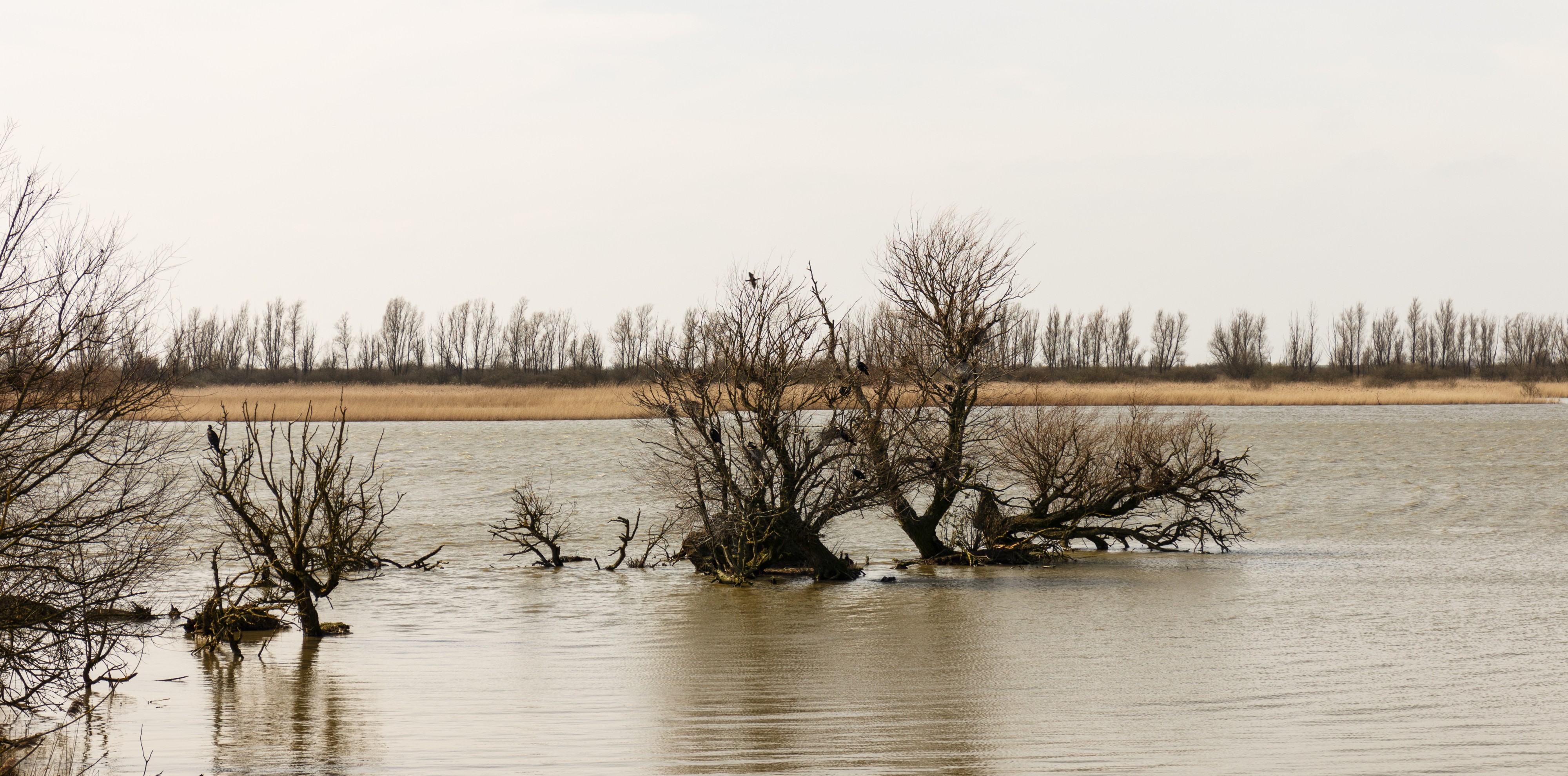
Nederlands: Oostvaardersplassen. Nieuwe natuur op de bodem van de voormalige Zuiderzee.
English: Oostvaardersplassen in the Netherlands. New nature at the bottom of the former Zuiderzee.
|
| Date | |
| Source | Own work |
| Author | Agnes Monkelbaan |
| Camera location | View this and other nearby images on: OpenStreetMap - Google Earth |
|---|
De Oostvaardersplassen vormen een natuurgebied van zo'n 5600 ha (56 km²) tussen Almere en Lelystad in de Nederlandse provincie Flevoland. Het gebied is ontstaan na de drooglegging van de Flevopolders (1950-1968) en dus relatief jong. De Oostvaardersplassen zijn van internationaal belang als moerasgebied en overwinteringsgebied voor vogels. Het gebied is ruwweg in twee gedeelten te onderscheiden: een nat (ca. 3600 ha) en een droog (ca. 2000 ha) gedeelte. Het droge gedeelte wordt gezien als een geschikte habitat voor grote grazers.
Het gebied is beperkt toegankelijk voor bezoekers en geniet wettelijke bescherming. Het is vrijwel geheel aangewezen als Vogelrichtlijngebied (5505 ha) en Staatsnatuurmonument (5600 ha). Sinds 1999 is het natuurgebied voorzien van het Europees diploma voor Natuurbeheer, een erkenning door de Raad van Europa die iedere vijf jaar wordt geëvalueerd. In 2009 zijn de Oostvaardersplassen definitief aangewezen als Natura 2000-gebied.
English:
The Oostvaardersplassen forms a natural area of approximately 5,600 hectares (56 square kilometers) between Almere and Lelystad in the Dutch province of Flevoland. The area is formed after the reclamation of the Flevopolders (1950-1968) and therefore relatively young. Oostvaardersplassen of international importance as a wetland area and wintering area for birds. The area can be divided roughly into two parts: wet (approximately 3600 ha) and dry (approximately 2,000 ha) area. The dry part is seen as a suitable habitat for large herbivores.<br /The area is restricted to visitors and enjoy legal protection. It is almost entirely designated as Special Protection Area (5505 ha) and State Natural Heritage (5600 ha). Since 1999, the natural features of the European Diploma for Nature, a recognition by the Council of Europe which is evaluated every five years. In 2009 Oostvaardersplassen identified definitively as a Natura 2000 site.
Licensingedit
|
I, the copyright holder of this work, hereby publish it under the following license:
|
|
This image has been assessed using the Quality image guidelines and is considered a Quality image. |
| EXIF data: | |
| File name | oostvaardersplassen._nieuwe_natuur_op_de_bodem_van_de_voormalige_zuiderzee_13.jpg |
|---|---|
| Size, Mbytes | 7.89892578125 |
| Mime type | image/jpeg |
| Camera manufacturer | Canon |
| Camera model | Canon EOS M |
| Image resolution in width direction | 240 |
| Image resolution in height direction | 240 |
| Unit of X and Y resolution | 2 |
| Exposure time | 1/320 sec (0.003125) |
| F number | f / 7.1 |
| Exposure program | 3 |
| ISO speed rating | 100 |
| Exif version | 0230 |
| Lens focal length | 47 mm |
| Date and time original image was generated | 2016:03:26 13:45:03 |
| Date and time image was made digital data | 2016:03:26 13:45:03 |
| Shutter speed | 8.321928 |
| Aperture | 5.655638 |
| Exposure bias | 0 |
| Maximum lens aperture | 4.875 |
| Metering mode | 5 |
| Color space information | 1 |
| Focal plane X resolution | 5798.6577181208 |
| Focal plane Y resolution | 5788.9447236181 |
| Focal plane resolution unit | 2 |
| Software used | Adobe Photoshop Lightroom 5.7 (Windows) |
| Copyright holder | Agnes Monkelbaan |
While the copyright and licensing information supplied for each photo is believed to be accurate, Free-Photos.biz does not provide any warranty regarding the copyright status or correctness of licensing terms. If you decide to reuse the images from Free-Photos.biz, you should verify the copyright status of each image just as you would when obtaining images from other sources.
The use of depictions of living or deceased persons may be restricted in some jurisdictions by laws regarding personality rights. Such images are exhibited at Free-Photos.biz as works of art that serve higher artistic interests.
PRIVACY POLICY
By registering your account and/or by subscribing to new and newly rated photographs you agree we may send you the links to photos and we may occasionally share other information with you.
We do NOT disclose your personal data.
