

Please login in order to download photos in full size
If you are not registered, please register for free: www.Free-Photos.biz/register
Please note to download premium images you also need to join as a free member..
You can also save the photos without the registration - but only in small and average sizes, and some of them will have the site's watermark. Please simply click your right mouse button and save the image.
Please login in order to like photos
If you are not registered, please register for free:
Sorry, non-members can download up to 1100 full-size photos per month.
It looks like you have used up your limit.
Free members can download an unlimited number of full-size photos - including the premium free photos.
Join as a member today for FREE! - and download the images without limitations:
www.Free-Photos.biz/membership.php
You can also save the images without the membership - but only in small and average sizes, and some of them may have the site's watermark. Please simply click your right mouse button and save the image.
|
This is a premium free photo
This photo was viewed times and was downloaded in full size 0 times.
This photo was liked 0 times


If you are a member, please login in order to see the source link of the above image.
| Artist | ||||||
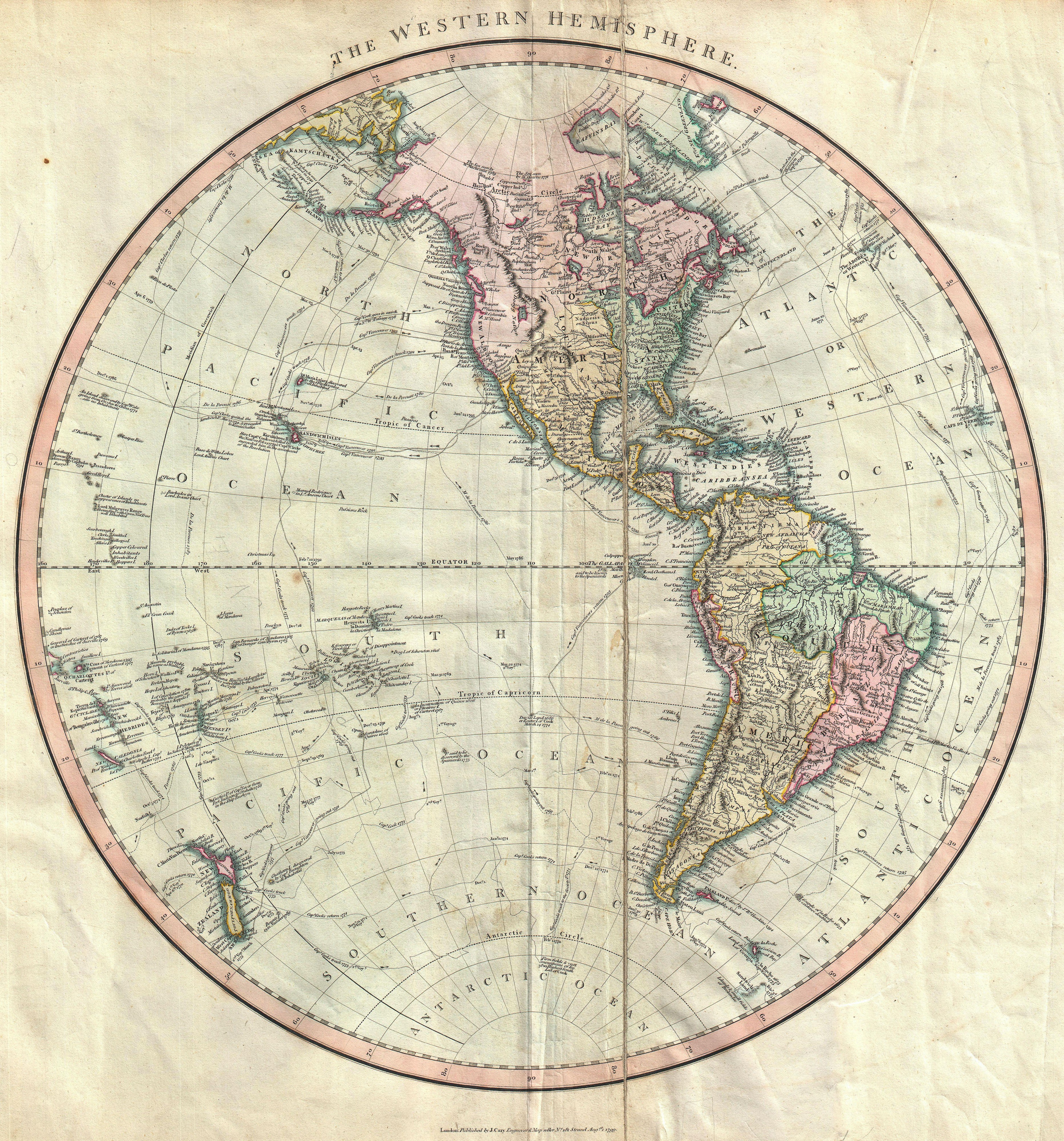
| Title | The Western Hemisphere | |||||
| Description |
English: An attractive example of John Cary’s spectacular 1799 map of the Western Hemisphere. Covers the entirety of North America, South America, the Pacific Ocean and much of Polynesia. Europe is mapped according to early 19th century form. In North America the fledgling United States extends westward only so far as the Mississippi River. Florida is divided at the Apalachicola River into eastern and western sections. West Florida, ostensibly part of the Louisiana Purchase, was claimed by the Spanish and remained under their control until 1812. East Florida remained under Spanish control until 1821. The South America portion of the map is notable for its excellent detail in the Amazon basin and the massive Spanish holdings extending from Panama south to Patagonia. The routes and discoveries of important explorers are noted throughout and crisscross both the Pacific and the Atlantic. Most notable are the explorations of Cook, Vancouver and Perouse. All in all, one of the most interesting and attractive atlas maps Western Hemisphere to appear in first years of the 19th century. Prepared in 1799 by John Cary for issue in his magnificent 1808 New Universal Atlas.
|
|||||
| Date | (dated) | |||||
| Dimensions | Height: 19.5 in (49.5 cm). Width: 18 in (45.7 cm). | |||||
| Accession number | Geographicus code: WesternHemisphere-cary-1799 | |||||
| Source/Photographer |
Cary, John, Cary's New Universal Atlas, containing distinct maps of all the principal states and kingdoms throughout the World. From the latest and best authorities extant. London: Printed for J. Cary, Engraver and Map-seller, No. 181, near Norfolk Street, Strand, 1808.
|
|||||
| Permission (Reusing this file) |
|
|||||
Public Domain
| EXIF data: | |
| File name | 1799_cary_map_of_the_western_hemisphere___america___polynesia___-_geographicus_-_westernhemisphere-cary-1799.jpg |
|---|---|
| Size, Mbytes | 8.347361328125 |
| Mime type | image/jpeg |
While the copyright and licensing information supplied for each photo is believed to be accurate, Free-Photos.biz does not provide any warranty regarding the copyright status or correctness of licensing terms. If you decide to reuse the images from Free-Photos.biz, you should verify the copyright status of each image just as you would when obtaining images from other sources.
The use of depictions of living or deceased persons may be restricted in some jurisdictions by laws regarding personality rights. Such images are exhibited at Free-Photos.biz as works of art that serve higher artistic interests.
PRIVACY POLICY
By registering your account and/or by subscribing to new and newly rated photographs you agree we may send you the links to photos and we may occasionally share other information with you.
We do NOT disclose your personal data.
